Cool Gauges on your GoPro Videos
For those of you who own a GOPRO camera, you probably know about the built-in GPS capability. If you are like me though, you may have tried to transfer some of the gauge data using the GOPRO software without much success. I wasn’t sure if it was a problem with the camera or the software until I did some research.
I don’t want to repeat the really good explanation which is provided by the software developer of the telemetry software I’m going to talk about here. I will provide you with the links below to the free light telemetry extractor and how you can include the gauges and charts from that into your GOPRO video and also links to the paid version which I recently purchased.
What is Telemetry? It is the process of recording and transmitting the readings of an instrument – in this case the GoPro. What telemetry does it record? Distance, speed, elevation, angle of bank, acceleration over time, date, g-force, track, heading and even camera information like heat and video type being filmed.
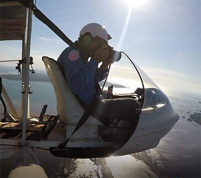
Dare I say that for a pilot, a GoPro can act as a “black box” flight recorder and unlike the real black boxes, which apparently are orange in colour – this is in fact black.
For those of you who are worried about the fact that you might need to upload your video to have the free telemetry extractor get the data from your video, it doesn’t upload the 4 or so gigabytes of a video to extract the data. Another thing I didn’t know was that the telemetry data like GPS location speed altitude and so forth are recorded and embedded into the video timecode providing you with valuable data plus the visual image of when and where the video was captured.
How I Tested the Solution
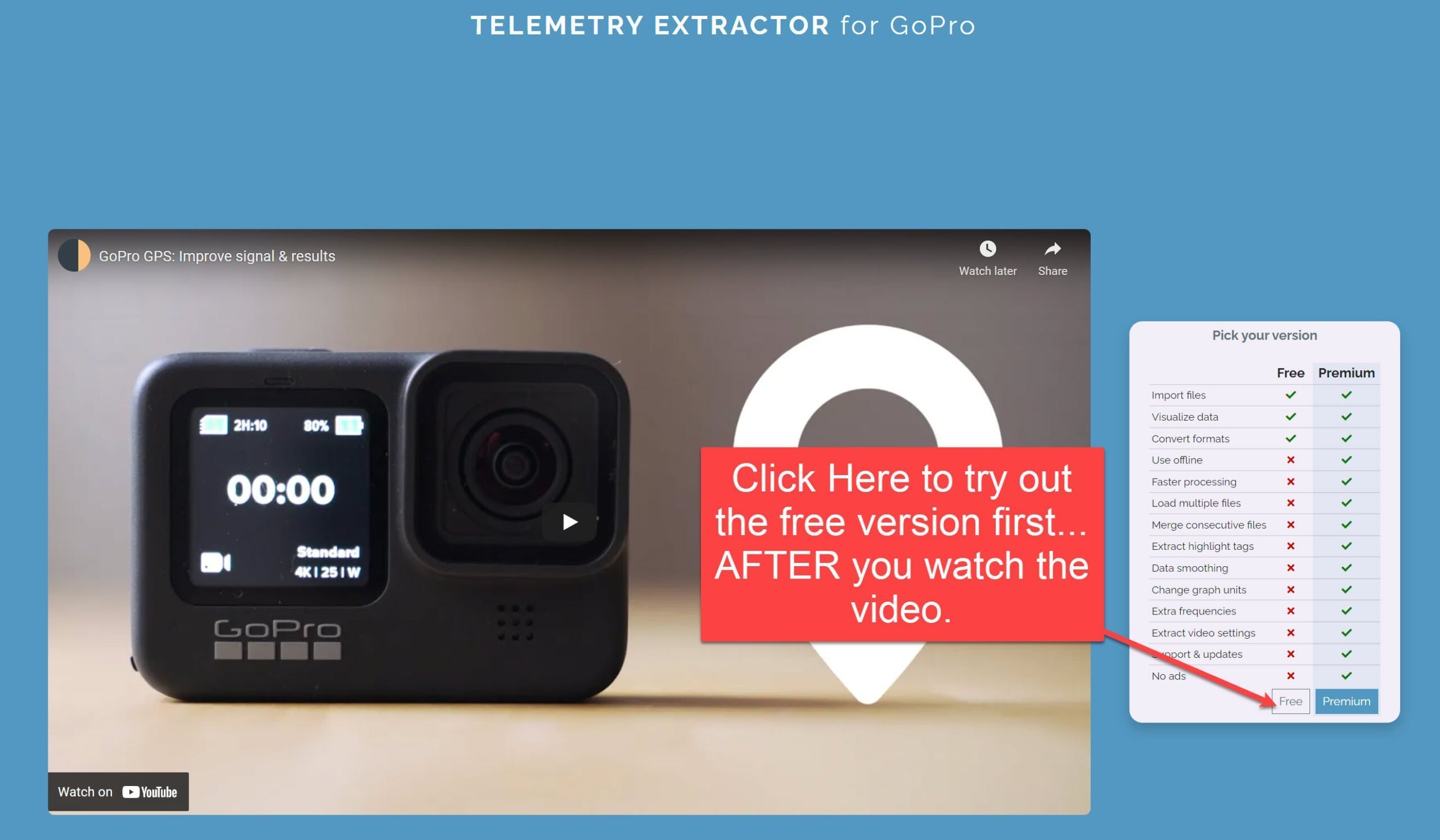
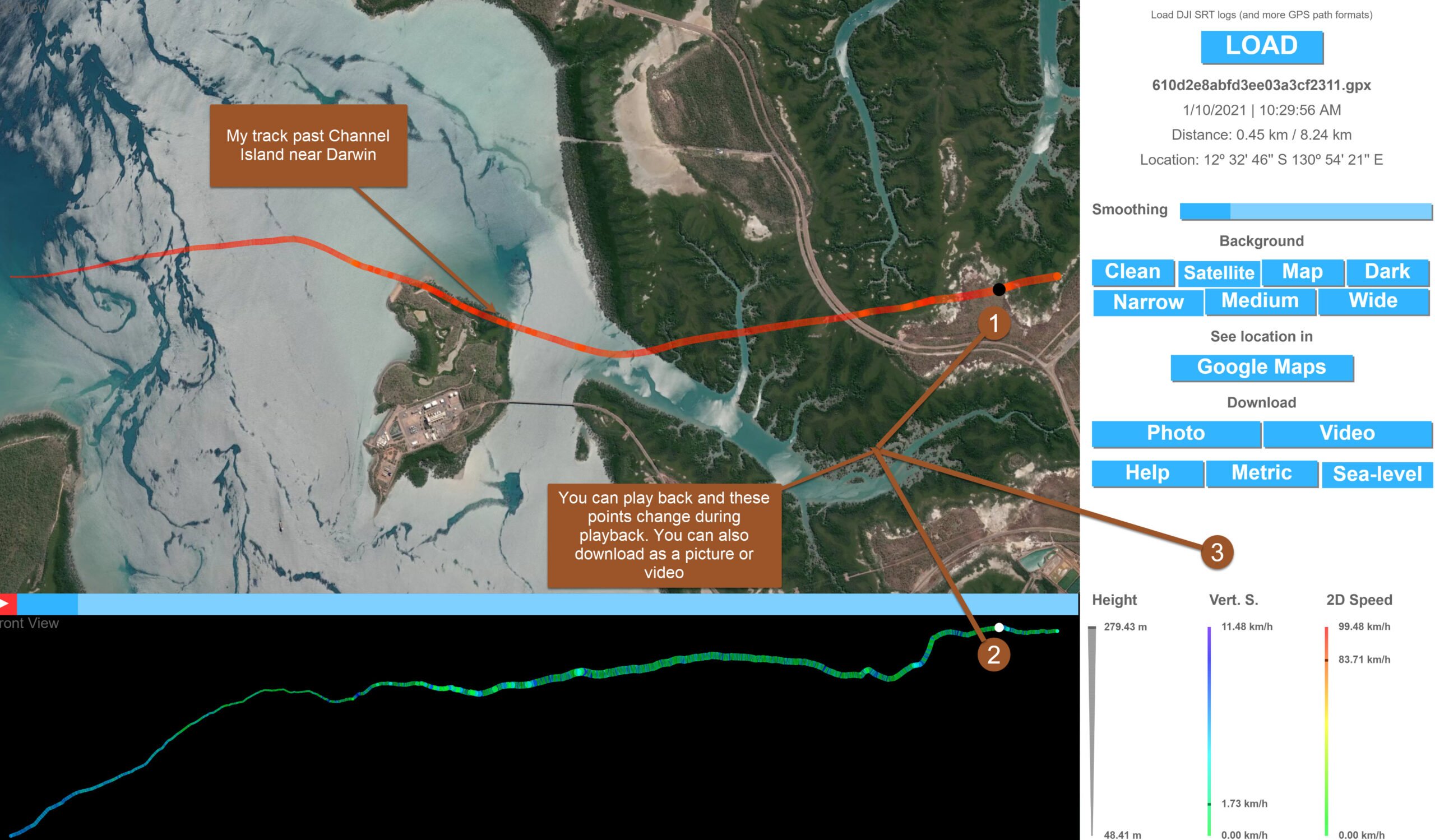
The way I approached trialling the solution before making the decision to purchase was to upload the telemetry from a video and then overlay that on to the software provided. I then downloaded the trial version of the telemetry extractor software which allows you to try out quite a few features but notably doesn’t include the underlying map for your track in that particular gauge overlay and also doesn’t allow you to join together several GOPRO videos which is typically the case when you film for an hour or so at high resolution. It also burns a watermark into any video that you output. That however is a very small price to pay for exploring the capabilities of this excellent software. You can also read the manual here.
Steps for Testing the Free Version
- Find a video that you shot with the GPS turned on when you shot it
- Go to Telemetry Extractor for GoPro (Lite) (goprotelemetryextractor.com)
- Watch the video, then click on the Free option and choose a video to upload.
- After uploading you will be presented with a number of options
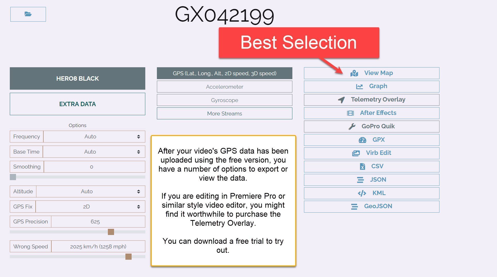
- After trying them out, click on the Telemetry Overlay Link in the right hand column to download a trial version of Telemetry Overlay. Or click on the link below.
Trial software expires after a few days and has the following limitations:
+ Expires after a few days
+ Adds a watermark to videos
+ Does not read consecutive files
+ Lacks some of the special gauges
+ Cannot export transparent (or chroma key) video/frames
+ GPS maps/satellite are not available
Use in Schools for Science and Sports Projects
Apart from providing data visualisations for the flights that I do, I realised that there was great potential and fun for students to use the solution to explore maths and physics by using a GOPRO. Whether it is running riding walking skateboarding or in my case flying data like elevation, acceleration, speed and GPS information including latitude longitude provides an incredible visual addition to the video footage displayed on the screen.
I have suggested to my son who is providing rowing coaching support for the high school students at his old school, Melbourne high school, that by attaching a GOPRO with the GPS switched on, to their boats, it becomes an incredible coaches review tool. It can also be an inspiration for students who can see their technique along with the telemetry data at exactly the same time, where they can highlight where things are going well and where things need improvement.
Interestingly, you can also import data from other devices such as a Fitbit. By merging GOPRO telemetry data with Fitbit data on the same screen you can get biological as well as telemetry results in grafts that appear on your video screen.
Workflow for the Paid Version
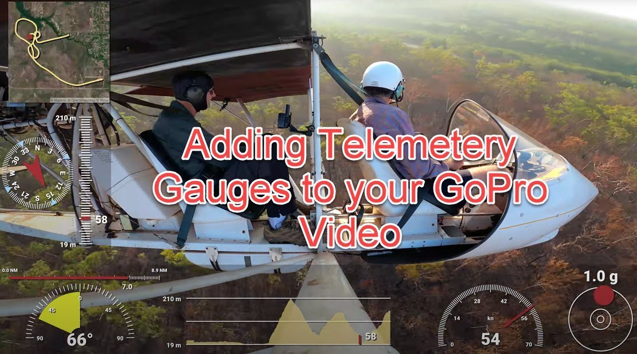
I worked out pretty quickly that this software was going to be useful for me, so I purchased it. This allowed me to add multiple videos at once, add resize and customise the gauges for each of the telemetry objects I wanted to add. My workflow was to view the help video, customise the gauges and then output as a transparent .MOV.
I then opened up the original file in Adobe Premiere Pro and added in the exported transparent.MOV which had the gauges that were then overlaid onto the video. I then added in titles at the start and an end screen along with some music and exported the video that you see below. I found the process intuitive and easy, but I do have a fairly powerful laptop and you might find that rendering these kinds of movies may take some time.
I have only produced a short test video using one of my recent flights, and considering that the GOPRO was facing inwards to the aircraft are not forward I was impressed with the data that was captured. At around AUD140 Australian for the paid version of the software license, it may not be for everyone. Given the complexity and level of customisation available within the product, I think it is money well worth spent. The gauges cab seen about 20 seconds into the video which was about Phil and I trying to locate a Jabiru nest I had seen near the end of MKT runway a week earlier.
GOPRO is focusing on the iOS and android versions of the app where apparently the gauges do work. I prefer to work on the PCs so was looking for a desktop based solution. There is talk of the new addition to the GOPRO app called Mural making its way into a PC and Mac version although I haven’t seen anything concrete about that.
Tools for Getting Telemetry from GoPro
One of the respected GOPRO forum folk posted a list of tools available for people to use to extract the telemetry data from the GOPRO. He kindly group that into basically easy and difficult to use. Here is that list
User friendly
- GoPro App Desktop / Android / iOS (Free) – Official editing tool. Can visualize some of the metadata, although many users have reported problems.
- Telemetry Overlay Windows / macOS (Paid / Trial) – Add customizable gauges to GoPro (and other cameras) videos
- GoPro Telemetry Extractor (Free/Premium) – Extract, visualize and convert any data stream (sensor) to other formats.
- GoPro GPS Quick Fix (Paid) – Modifies your video files to enable gauges / performance stickers in GoPro Quik.
- Virb Edit (Free) – Overlay nice gauges on videos. GPS data must be converted to GPX first.
- Dashware (Free) – Combine video and gauges. Data must be converted to compatible formats first.
- Serious Racing (Free) – Online lap timer. Reads GPS data.
- Race Technology (Paid) – Offline lap timer and other sensor data.
- Drone Viewer (Paid) – Reads and displays GPS data alonside the video.
- Race Render (Trial/Paid) – Offline lap timer. GPS data must be converted to GPX first.
- After Effects Telemetry template (Lite/Paid) – Customizable After Effects overlay for visualizing multiple data streams.
- Lap Analyser (Free) – Gets lap times, forces and angles from motorsports footage (cars/motorcycles)
- The Video Map (Free) – Watch your youtube videos alongside a location map
- Map the Paths Uploader – Put your images and video “on the map”
For developers
- gopro-telemetry – JavaScript tools for extracting any data stream.
- gpmf-parser – C++ sample project and documentation on the GoPro Metadata Format.
- gopro-utils – GoLang tools for extracting some of the data streams, plus batch tool for automating the process on Windows.
- gopro2gpx – Python tool for converting the GPS data into GPX.
- gpmf-extract – JavaScript tool for extracting the binary data from the mp4 when ffmpeg is not available.
A lot of fun and adds real value to an already amazing tool. I take my hat off to the developer of the software.
Let me know what ideas you have for using GoPro telemetry in education.